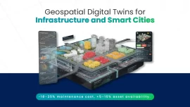

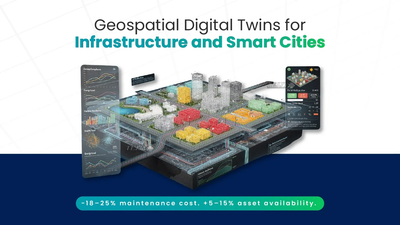
What is a Geospatial Digital Twin?
As cities expand and assets age, the next infrastructure upgrade is smart and digital. The kind that can “see” itself and predict what happens next. And digital twins help manage this in a real-time AECO environment.
A geospatial digital twin is a digital representation of physical infrastructure systems integrated with as-is geographic context. As opposed to BIM for infrastructure which is static in nature, or conventional GIS maps, this dynamic technology acts as an intelligent infrastructure digital twin platform. Integration of engineering data with reality capture for infrastructural upgrades turn this smart city digital twin into a unified environment.
This digital infrastructure ecosystem is an amalgamation of
- BIM for asset-level precision
- GIS for terrain and environmental datasets
- IoT-enabled infrastructure monitoring
- Reality capture workflows
With systems like drone surveys and satellite-derived data, geospatial digital twins enable city-scale digital twin modeling and smart infrastructure analytics. As Paul Becker, President of the Federal Agency for Cartography and Geodesy (BKG), notes:
“Digital twins allow a completely new form of data transfer. We know how important it is to make quick and precise decisions to tackle global challenges today.”
In essence, geospatial digital twins transform public infrastructure into predictive systems that support resilient urban development.

Role of Geospatial Digital Twins in Infrastructure Projects
Large-scale infrastructure has evolved from isolated project execution to integrated lifecycle stewardship. Today’s civic assets and utility systems operate within dense urban environments. Transportation networks are shaped by regulatory pressure and rising service expectations. A GIS integrated digital replica addresses this complexity by serving as a strategic digital twin for public infrastructure across the project lifecycle.
Key Contributions:
- Elevates strategic planning: Enhances smart city infrastructure planning by embedding geographic, environmental, and utility data into early feasibility assessments.
- Strengthens cross-disciplinary coordination: Connects civil, structural, and MEP datasets within connected infrastructure ecosystems.
- Enhances construction oversight: Enables real-time infrastructure monitoring, allowing project teams to compare performance metrics within a unified digital environment.
- Advances operational intelligence: Supports infrastructure performance analytics, empowering asset owners to performance-based management.
- Improves lifecycle predictability: Facilitates scenario analysis and long-range forecasting, strengthening capital planning.
By integrating spatial context with operational insight, geospatial digital twins reposition infrastructure projects as data-governed systems rather than static assets.
Geospatial Digital Twin vs BIM vs Traditional GIS Mapping: Key Differences Explained
| Category | Building Information Modeling | Traditional GIS Mapping | Geospatial Digital Twin |
|---|---|---|---|
| Core Function | Develops detailed engineering intelligence models for asset design and coordination | Manages large-scale geographic data systems for mapping and spatial analysis | Unifies engineering and spatial intelligence through BIM-GIS integration |
| Typical Scale | Individual infrastructure assets like bridges, stations, plants, etc. | Corridor, district, city, or regional scale | City-scale and network-scale infrastructure ecosystems |
| Real-Time Capability | Primarily static unless manually updated | Primarily static mapping layers | Dynamic model enabling monitoring, simulation, and analytics |
| Lifecycle Scope | Design and construction focused | Planning and spatial assessment focused | Enables lifecycle-based infrastructure modeling from planning through long-term operations |
How Do Geospatial Digital Twins Improve Smart City Infrastructure and Asset Management?
Fragmented planning approach is no longer a feasible option for infrastructure asset management. This is because today’s cities are scaling at an increasing rate with public works and civic and federal facilities becoming interdependent. With the digital trinity of engineering, spatial and operational intelligence forming an alliance in urban digital twin technology, the infrastructure becomes reliable and measurable.
BIM-GIS-IoT Data Convergence for Building City-Scale Infrastructure Digital Twins
City-scale digital twins become viable when BIM–GIS integration is combined. Building Information Modeling contributes to engineering intelligence; GIS provides geographic context, and IoT streams add operational visibility. This creates a stable and solid foundation for network-level infrastructure insight. This convergence builds on the location-driven principles discussed in GIS for Smarter Public Utility Infrastructure, where spatial data integration strengthens coordination.

Geospatial Digital Twin Use Cases in Transportation Networks, Utilities, and Smart City Planning
- Transportation Networks:
- Enables transportation corridor modeling by fusing traffic counts, signal timing, incident feeds, and work-zone phasing.
- Georeferenced asset inventories to test bottleneck fixes, level-of-service forecasts, and expansion scenarios.
- Utilities:
- Supports utility network optimization by linking hydraulic-electrical models with IoT telemetry.
- Identifies constraint zones, validate valve-switch isolation, and prioritize upgrades using utility mapping for large-scale infrastructure.
- Smart City Planning:
- Strengthens smart city infrastructure planning.
- Combines zoning, land-use change, growth projections, and climate risk layers for resilience-driven capital phasing.

Predictive Asset Lifecycle and Performance Management with Geospatial Digital Twins
Geospatial digital twins support predictive asset lifecycle management by integrating condition metrics, geospatial datasets, and real-time telemetry. They model asset degradation patterns and trigger timely, data-driven interventions. This improves infrastructure performance forecasting. For subsurface systems, LiDAR-driven asset management for underground utilities shows how reality capture and spatial analytics enhance visibility, prioritization, and long-term reliability.

Key Challenges and Practical Solutions for Large-Scale Infrastructure Projects
City-scale deployment of a geospatial digital twin works only when data, security, and operations are designed as first-class requirements.
- Data interoperability challenges: Inconsistent schemas and asset IDs across BIM weaken BIM-GIS integration. Standardize identifiers, map schemas, and enforce interoperability.
- Legacy infrastructure digitization: Incomplete as-builts and outdated GIS layers reduce baseline accuracy. Prioritize critical assets and update existing conditions using reality capture workflows.
- Cybersecure infrastructure ecosystems: Real-time feeds expand exposure across cloud, vendors, and SCADA interfaces. Apply zero-trust access and audit logging at integration points.
- Scalable digital twin architecture: City-scale models require heavy storage to stay decision-grade. Use cloud-native pipelines and governance rules to maintain accuracy.
Solving these early turns pilots into enterprise-grade geospatial digital twins that support lifecycle-driven infrastructure performance.
From Digital Models to Infrastructure Intelligence
The next infrastructure advantage will not come from building faster; it will come from operating smarter. Geospatial digital twins create the decision layer cities need to manage complexity, climate risk, and constrained capital with measurable accountability. As adoption matures, the differentiator will be governance: who can turn integrated data into repeatable, lifecycle outcomes. The cities that master this will move from “smart” as a label to smart as an operational standard.
FAQ
How do geospatial digital twins reduce RFIs, change orders, and rework in large infrastructure projects?
Geospatial digital twins reduce RFIs and rework by aligning georeferenced BIM models with real-world site conditions and utility datasets before construction begins. By integrating real time reality capture updates, teams can coordinate across disciplines in a shared digital environment. This minimizes scope gaps, improves constructability reviews, and reduces costly field corrections.
What is the best workflow to align georeferenced BIM with corridor GIS for highways, rail, or utility corridors?
The optimal workflow begins with establishing a common coordinate reference system and standardized asset IDs. BIM models are then georeferenced and integrated into GIS platforms using schema mapping and interoperability standards. Corridor-level datasets are merged into a shared spatial data environment. Continuous validation ensures engineering models remain synchronized with geographic data systems across the lifecycle.
How can GIS integrated reality capture improve construction verification and as-built updates in a infrastructure digital twin?
Reality capture technologies, such as drone surveys, LiDAR datasets, and photogrammetry, provide accurate, field-verified data that can be compared against design models. By integrating these updates into a geospatial digital twin, project teams can validate installation and maintain a continuously updated as-built record. This strengthens quality assurance and ensures operational models reflect actual site conditions.
How do smart city digital twins support permitting, environmental compliance, and stakeholder approvals?
Geospatial digital twins for permitting services consolidate zoning data, environmental constraints, utility networks, and proposed designs within one spatial framework. This allows agencies to simulate environmental impacts, assess right-of-way conflicts, and evaluate regulatory constraints before submission. By presenting data-backed visualizations and performance metrics, stakeholders gain transparency, accelerating review cycles and improving approval outcomes.
How can owners transition from project BIM deliverables to an operational GIS digital twin?
Transitioning requires structuring BIM deliverables around asset IDs, metadata standards, and lifecycle requirements rather than design-only outputs. Integrating BIM with GIS and operational systems creates a foundation for lifecycle-based infrastructure modeling. When connected to IoT-enabled infrastructure monitoring and asset management platforms, the digital twin evolves from a project model into a performance-driven operational system.