


Florida’s Trusted BIM Company for Design, Construction & Facility Management
Professional Building Information Modeling and geospatial data integration services for construction excellence.
Request a Consultation


Full-Lifecycle BIM Solutions in Florida for Design, 3D Visualization, and Building Coordination.
Tejjy Inc. delivers advanced BIM solutions across Florida, helping AEC teams design, coordinate, and manage buildings with data-driven accuracy

Our expertise spans 3D modeling, Scan-to-BIM, digital construction workflows, and integrated facility operations.
- Delivering Revit BIM expertise across Florida, including Jacksonville, Miami, Tampa, Orlando, and St. Petersburg.
- An 8(a) certified AEC firm and Women-Owned Business Enterprise (WBE) committed to industry-standard quality and reliability.
- Providing on-site and off-site BIM solutions spanning 3D modeling, 4D scheduling, 5D cost estimation, and facility management.
- Utilizing Autodesk Revit, Navisworks, and advanced BIM/VDC software to support diverse project types, residential, commercial, industrial, infrastructure, and healthcare.
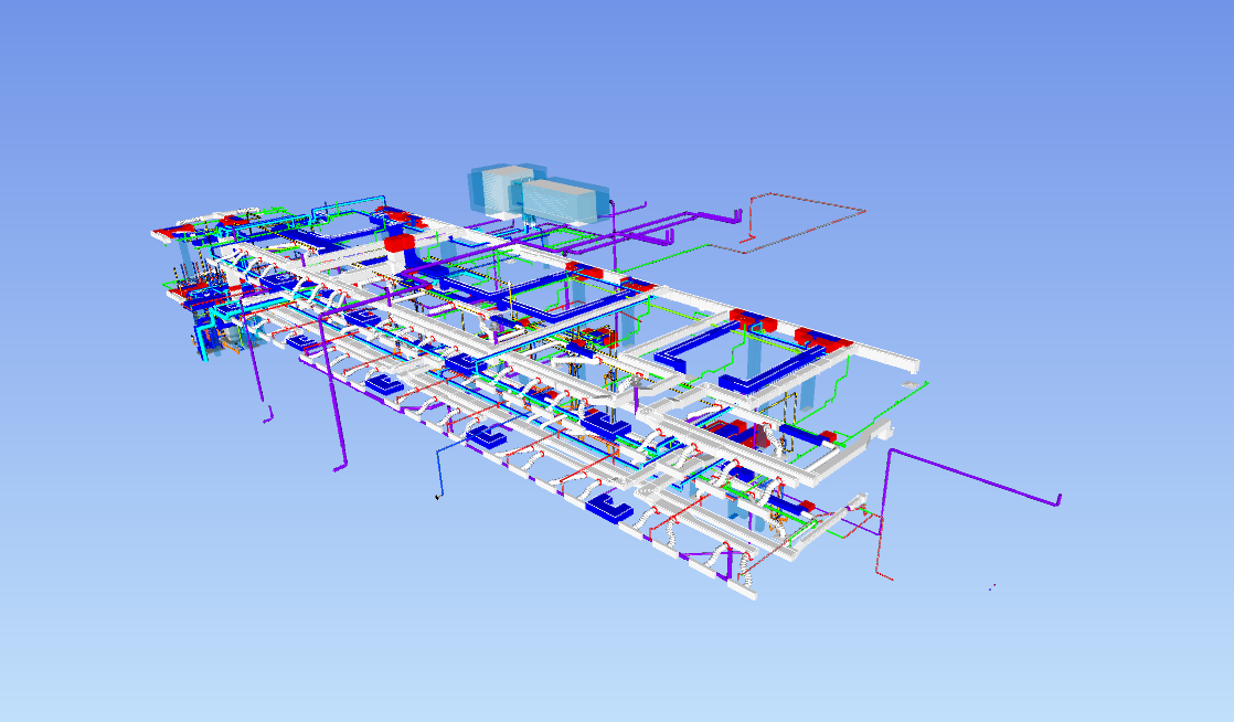
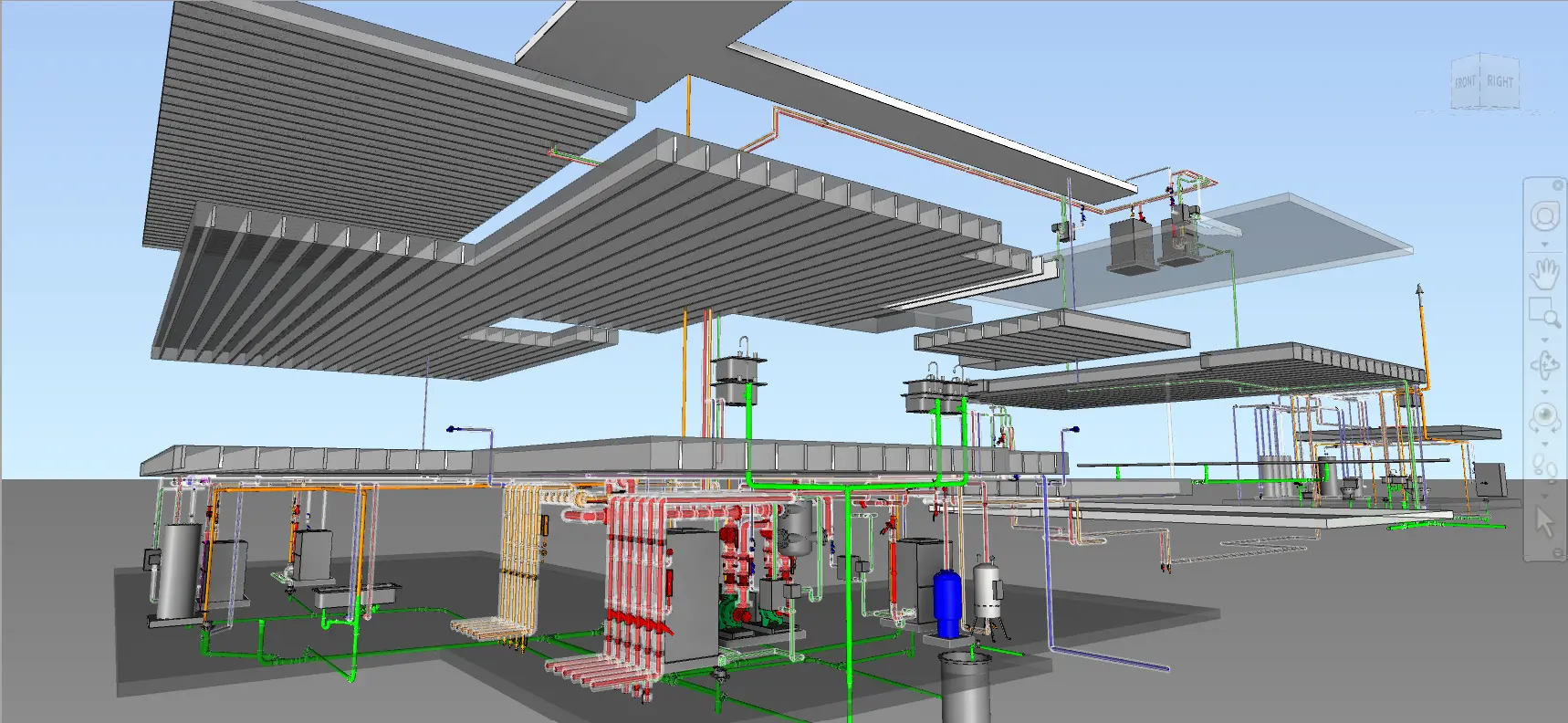
As a leading BIM company in Florida, Tejjy provides full-lifecycle Building Information Modeling, VDC engineering, Scan-to-BIM, and Digital Twin services for complex AEC projects. Our specialists deliver Revit Modeling from LOD 300–500, point cloud to BIM conversion, coordinated MEPF systems, clash detection, 4D scheduling, 5D cost estimation, construction documentation, and facility management integration, supporting accurate planning, predictable execution, and long-term operational efficiency.
Explore Our ServicesOur BIM Modeling & Coordination Services in Florida
Delivering comprehensive BIM services with precision and expertise for Florida’s construction industry.
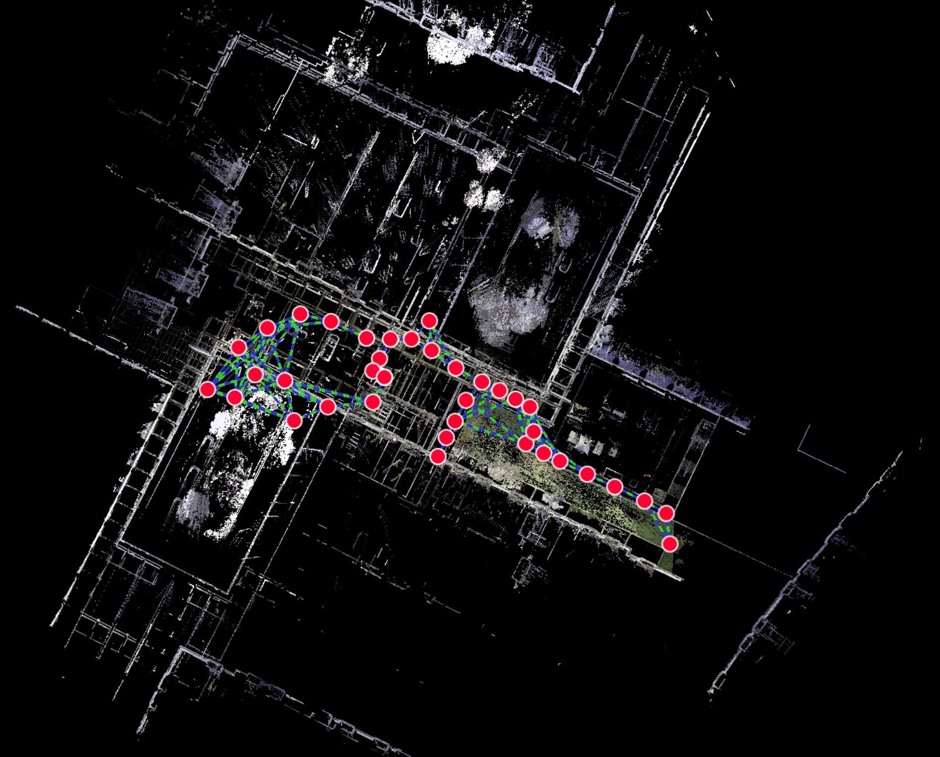
Scan to BIM / Scan to CAD
High-accuracy point cloud capture, LOD 300–500 as-built BIM models, 2D CAD plans, sectional datasets, and verified existing-conditions documentation.
BIM Consulting
BEP creation, BIM standards/templates, model audits, workflow optimization, and constructability review datasets for seamless BIM adoption.
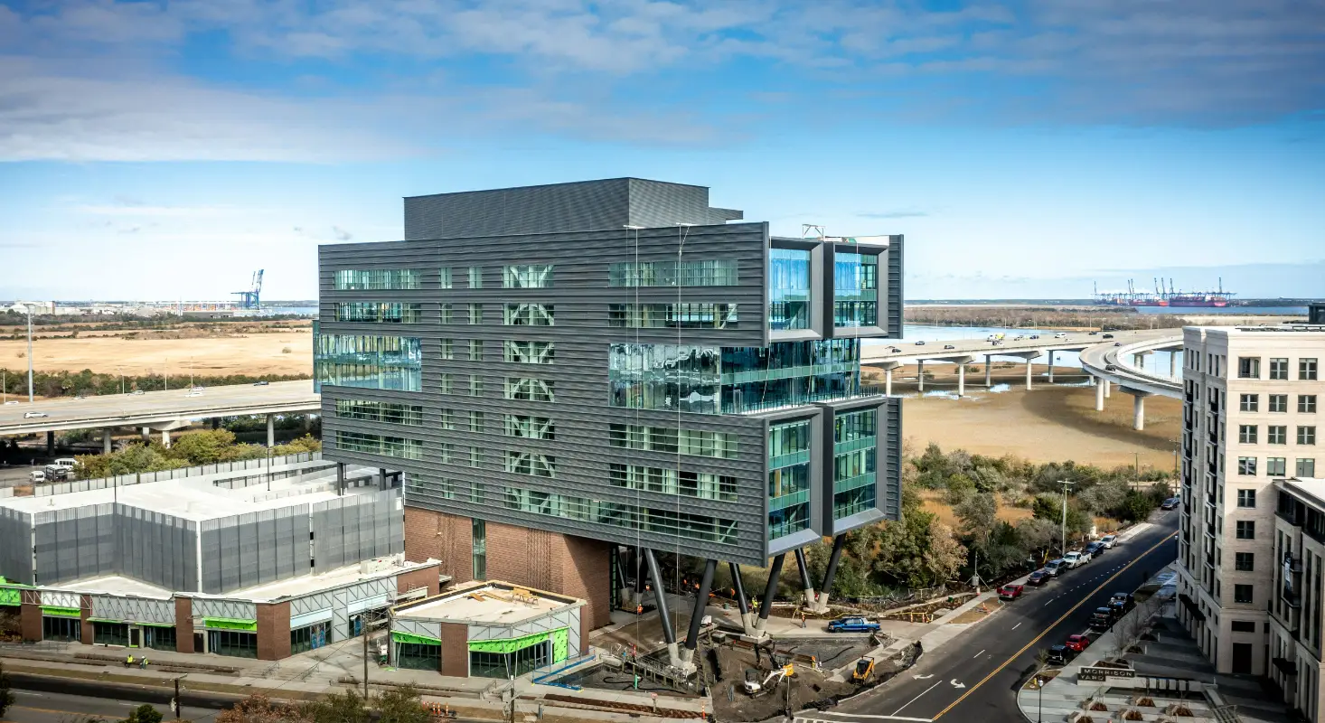
Architectural BIM Modeling
LOD 300–500 architectural models, adaptive Revit families, façade elevations, coordinated drawing sets, and visualization-ready 3D datasets.
Structural BIM Modeling
LOD 300–500 structural models, rebar detailing, steel shop drawings, COBie-enabled parameters, and fabrication-ready structural datasets.
Revit Family Creation
Custom parametric Revit families, lightweight BIM objects, manufacturer-specific components, and optimized content libraries for project reuse.
MEP BIM Modeling
LOD 300–500 HVAC, electrical, plumbing & FP models; coordinated MEP layouts; spool/fabrication drawings; and metadata-rich component datasets.
BIM Coordination & Clash Detection
Federated model creation, clash matrices, Navisworks clash reports, discipline-specific resolutions, and 3D constructability-verified datasets.
4D & 5D BIM Services
4D sequencing models, time-linked simulations, 5D cost-loaded BIM datasets, real-time quantity takeoffs, and project-phasing deliverables.
Shop Drawing Services
Architectural, structural & MEP shop drawings; coordinated layout plans; fabrication details; sleeve/penetration drawings; and permit-ready documentation.
How BIM Services Florida Boost Project Accuracy and Compliance
Transforming Florida’s construction landscape with advanced BIM, Scan-to-BIM, and LiDAR technologies tailored to complex site conditions.

500+
Coastal & Urban Complexity
BIM workflows optimized for coastal-resilience, high-density, and adaptive-reuse projects
200+
Sector-Wide Demand
Supporting hospitality, healthcare, aviation & industrial expansions across Florida
15+
Infrastructure-Ready BIM
Geospatial mapping, 4D sequencing & clash detection for highway and resilience upgrades
98%
Regulatory Alignment
Compliance-ready BIM datasets meeting Florida Building Code & environmental standards
Tejjy’s BIM, Geospatial, and Digital Engineering Services for Florida’s Key Industries
Serving diverse sectors with specialized BIM solutions tailored to industry-specific requirements and standards.
- Data Centre
- Commercial
- Healthcare
- Industrial
- Education
- Airports & Transits
- Heritage & Mueseums
- Hotels & Retail
- Warehouse
- Residential
- Oil & Gas
- Water Treatment
- EV Charging
- Infrastructure
- Federal & Public
- Telecom
- Utilities & Energy
- Entertainment Venues
- Roads & Bridges
- Defense
- Manufacturing Plants
- Real Estate
- Auditoriums & Centers
- Mixed Use
High-Accuracy BIM Projects Delivering Scan-to-BIM, Digital Twins, and MEP Coordination
Why Hire Tejjy for BIM & Digital Engineering Services in Florida
We deliver precision-driven BIM modeling, point cloud processing, MEPF coordination, and infrastructure-ready data integration tailored to Florida’s regulatory, coastal, and high-growth construction environments.
Advanced BIM Modeling
Revit LOD 300–500 architectural, structural, and MEPF modeling supporting permitting, coordination, fabrication, and facility management workflows.
Scan-to-BIM & LiDAR Processing
High-accuracy point cloud capture, registration, noise cleanup, and conversion into verified as-built BIM models for renovations and existing facility documentation.
Technical Experience & Certifications
8(a) certified AEC firm with 19+ years of industry expertise and 2500+ BIM, VDC, and scanning projects delivered across commercial, infrastructure, and public-sector markets.
Digital Construction & Data Integration
4D sequencing, 5D cost-linked BIM, clash resolution matrices, GIS-BIM fusion, COBie asset data structuring, and Digital Twin-ready datasets for resilience and infrastructure projects.
Choose Tejjy Inc. For Precision Scan-to-BIM In Florida
Fast, accurate BIM models for design, construction, and facility management.
Get in Touch
Ready to start your project? Contact us for a free consultation and quote.
Send us a message
Contact Information
Our Office
1 Research Ct, Ste 335, Rockville MD 20850
Phone
Business Hours
24hrs


